The World’s Most Dangerous Footpath: Walking the Caminito del Rey

The wind whipped by me as the park attendant handed me back my camera, dislodging my lens cap. As if in slow motion, I imagined it careening down the gorge and ending up passing through the hydroelectric plant to the south. 

Instead, it landed in the cracks between the newly placed wooden planks that made up the boardwalk. I breathed a sigh of relief.

“That was close,” the monitor said, stooping to retrieve it. “It’s 110 meters to the bottom.”

El Caminito

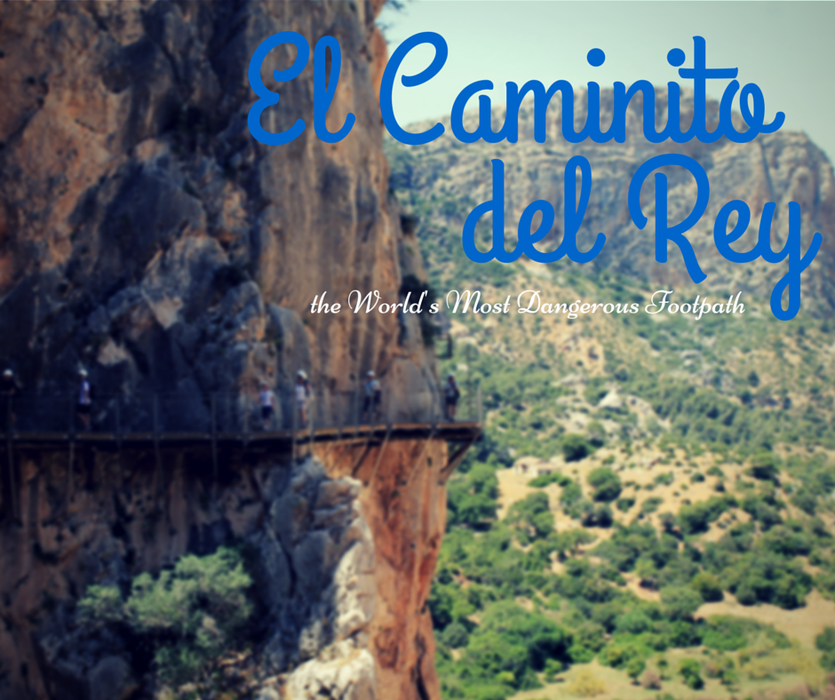
Even though planning my wedding and buying a house has left me pretty grounded, I prescribe to the “Have car, will explore” philosophy. When I heard about El Caminito del Rey, buried deep in the Málaga province, I wanted to plan a visit to what’s been known as one of the most dangerous hikes in the world.

Originally inaugurated over a century ago, this one-meter wide walkway became infamous internationally when five climbers fell to their deaths between 1999 and 2000. A decade passed before the Junta de Andalucía and the Diputación de Málaga agreed to saddle the costs of repairing the footpath that was christened with its present name after King Alfonso XIII traversed the one-meter wide trail when inaugurating the dam.

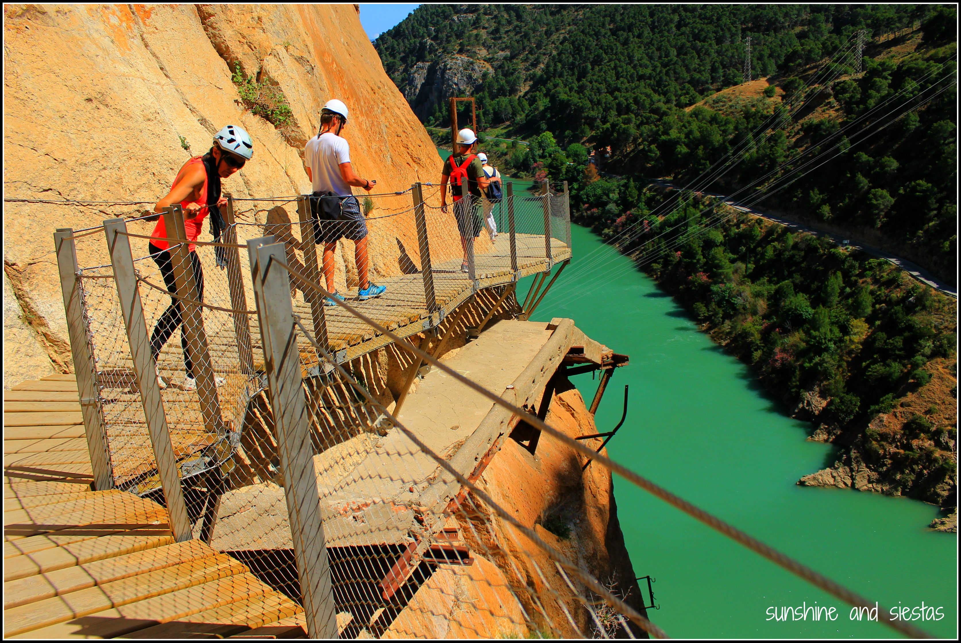
The Caminito fell into disrepair due to its hastily constructed path of concrete and sand, rendering it extremely risky to anyone who had the gall to pass it. I’ve seen images of climbers scaling rock faces, teetering over rusted metal rails and even perched on the edge of the balcones.

But by the time I was ready to try, the path was scheduled for a huge face lift.


Entering El Chorro from Ardales, the one-lane path climbed steeper and turns became tighter. Almost at once, my car was plunging into a valley of pine trees and slate a I watched the kilometer signs tick closer and closer to zero.

Then I got caught behind an interurban bus, a true sign that the Caminito del Rey is now accessible to anyone who can walk and not give in to vertigo.

A view of the Desfiladero de Gaitanes

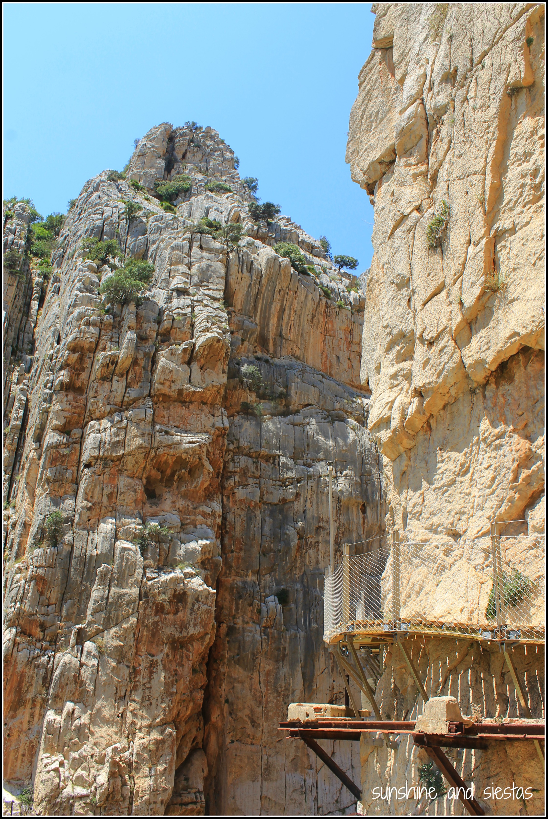
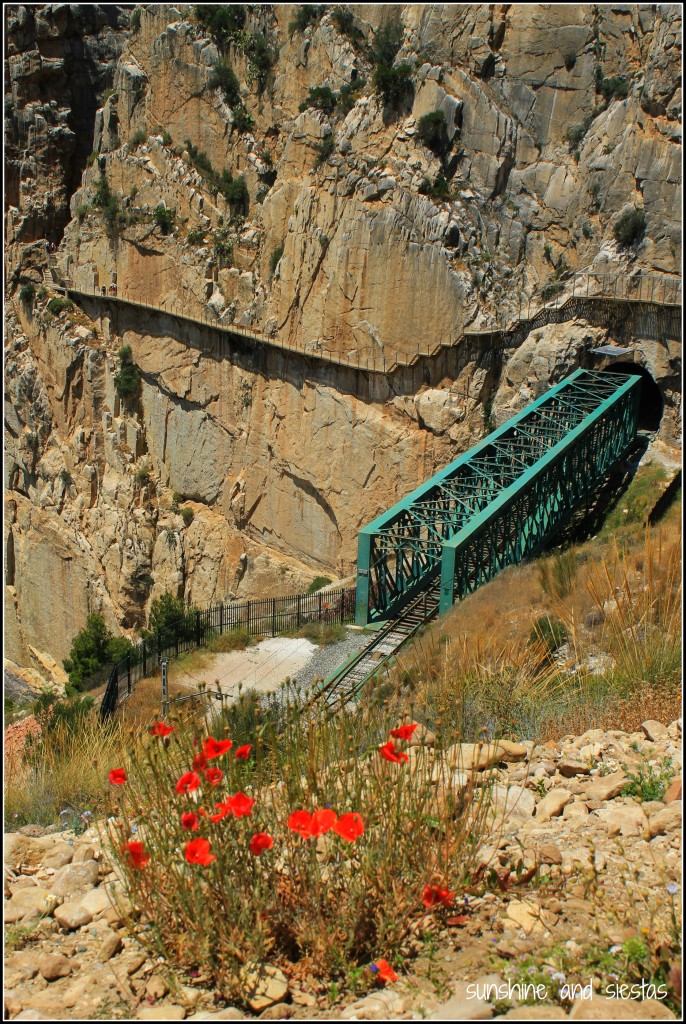
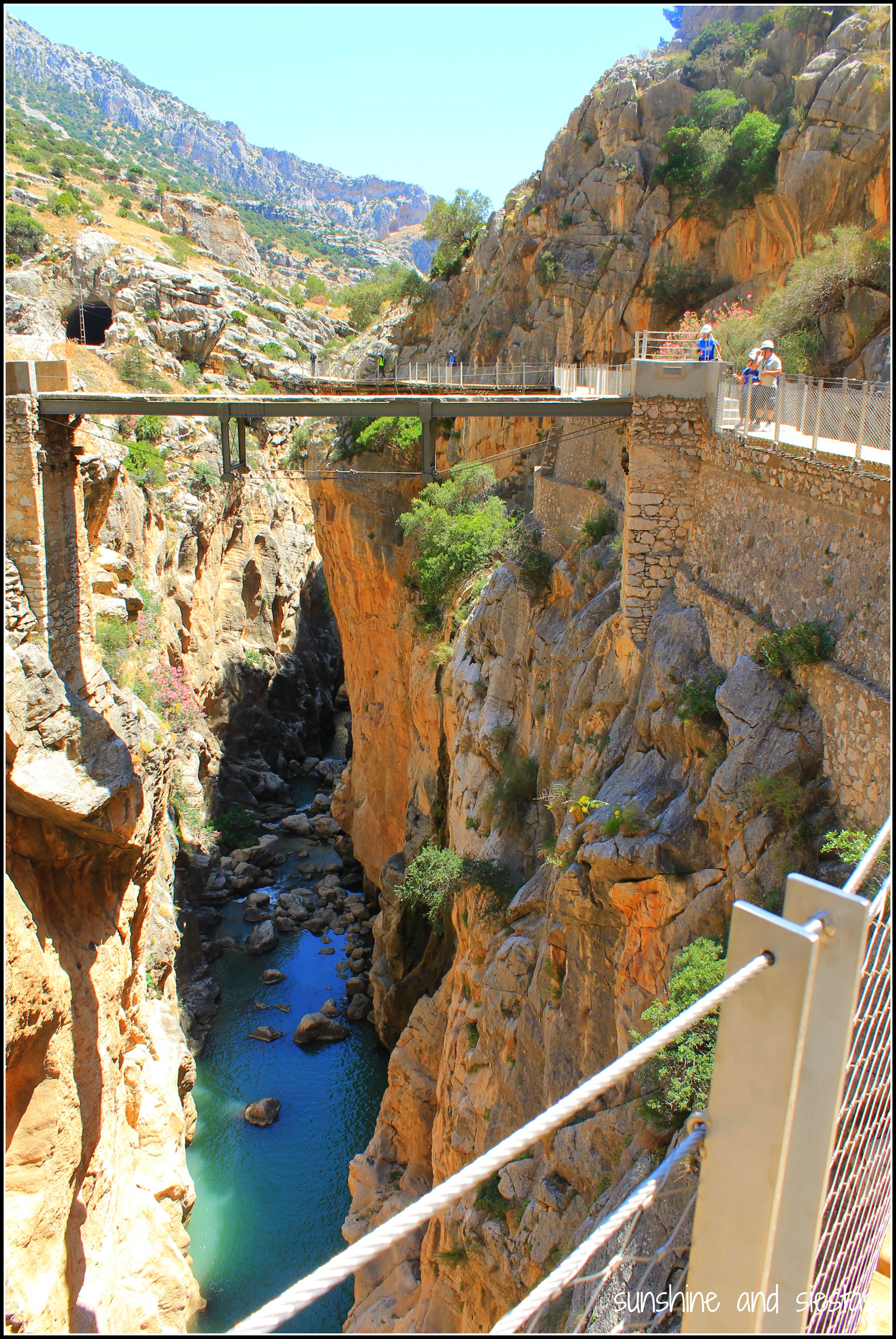
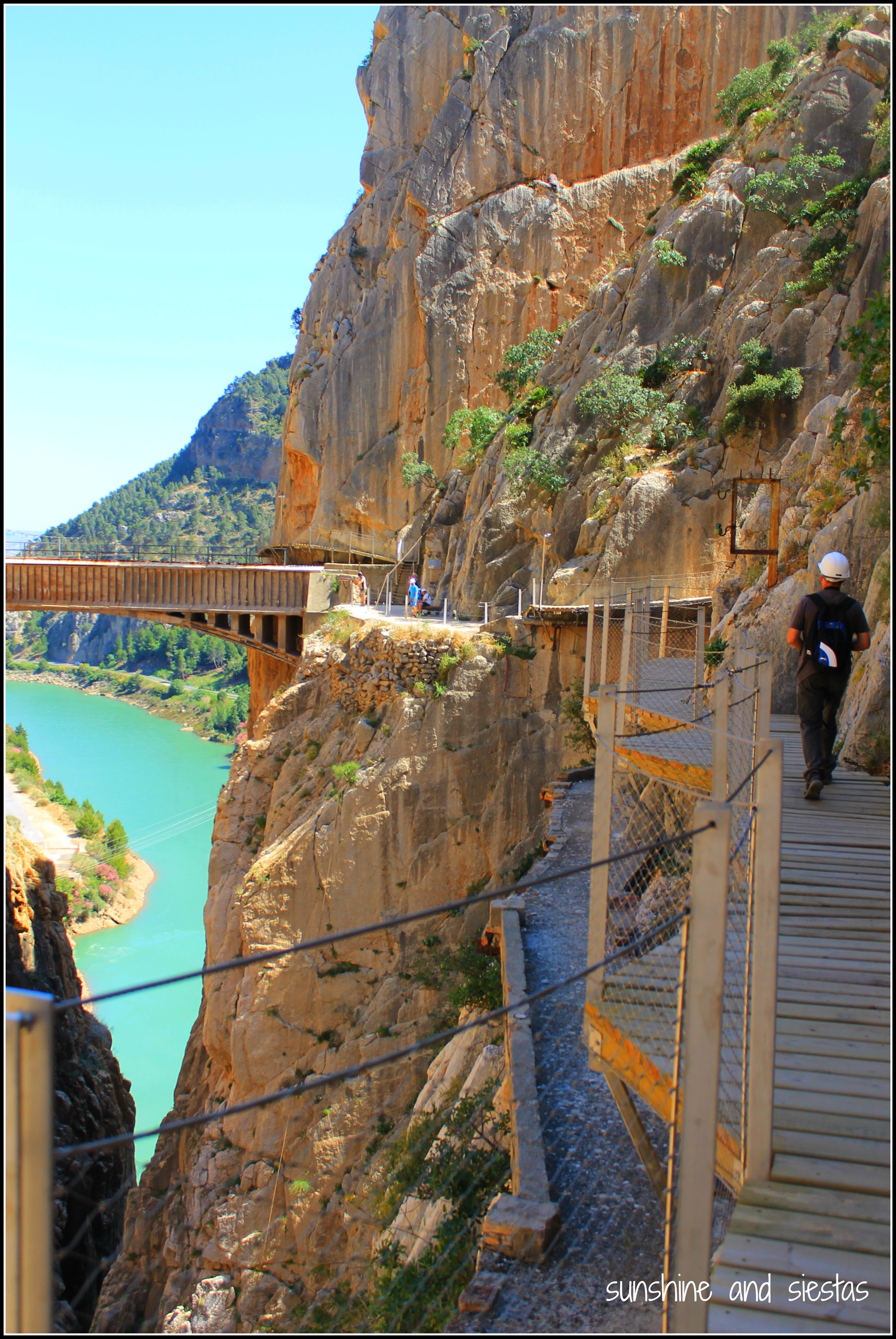
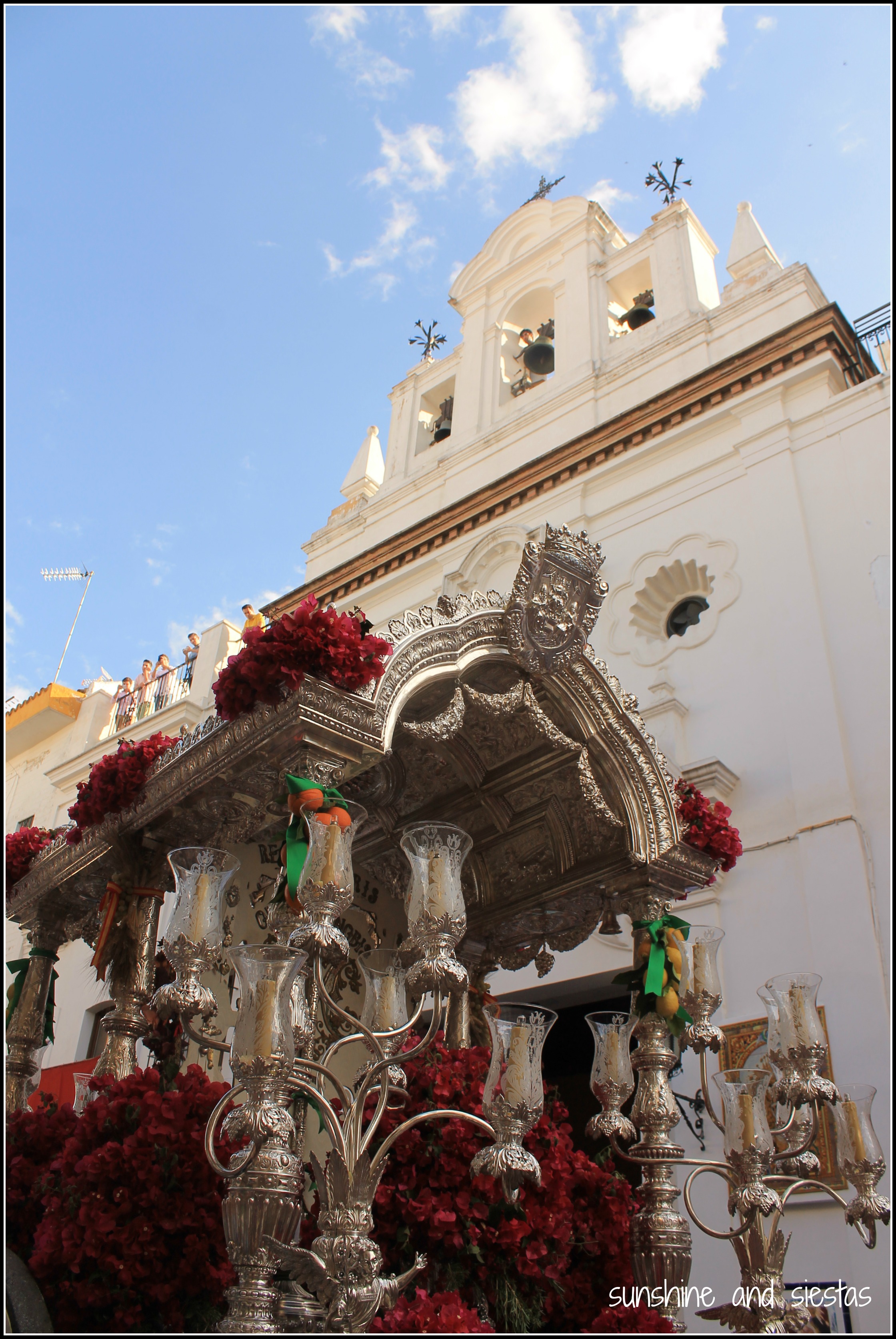
I rounded the bend after the Virgen del Valverde hermitage, and my car spit me out onto a wider paved road. I immediately saw the small crack in the cliff that made up el Desfiladero de los Gaitanes, the old rickety pathway just beneath a more linear, safer replacement and the famous bridge between the two rock faces.

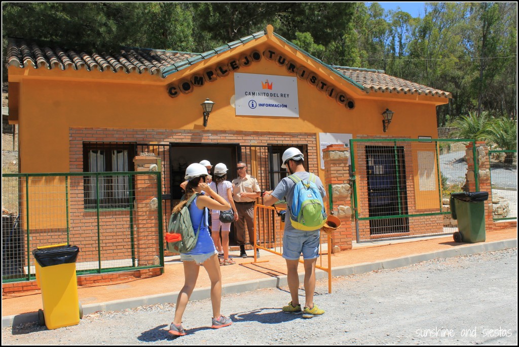
My GPS had long stopped giving me precise location updates, so I found a place to park near the visitor’s cabin nearly 90 minutes before my assigned entrance time at 2pm. 

protective headgear for the Caminito del Rey

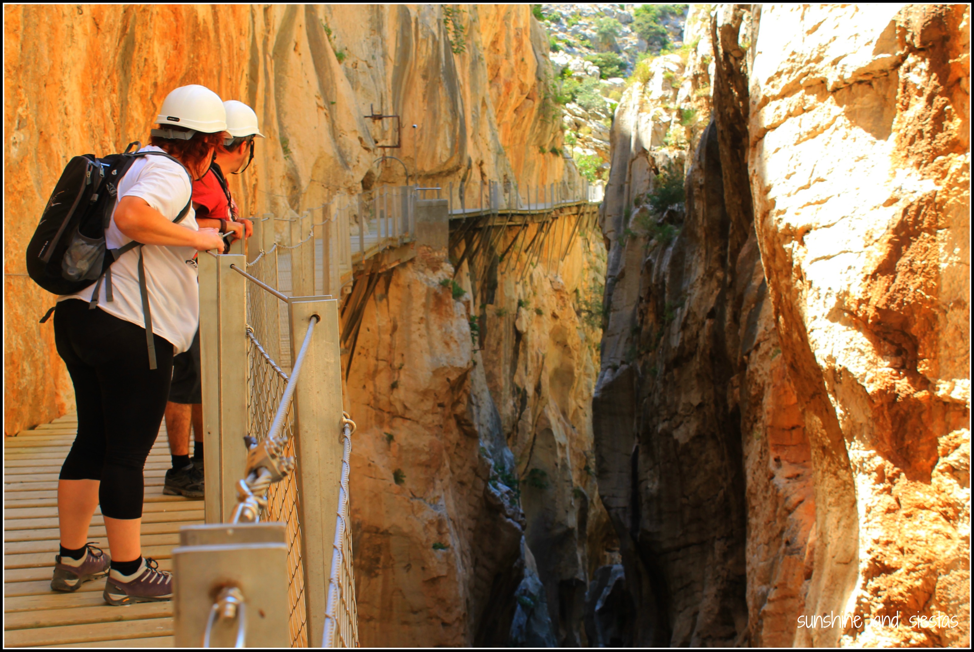
Safety precautions have made El Chorro’s big draw a bit lackluster. Rockslides, jumpers, wind and other natural elements have been controlled, experienced climbers hired as monitors and protective helmets purchased for every hiker. If not for the thrill, go for the views.

Hiking to the Caminito del Rey

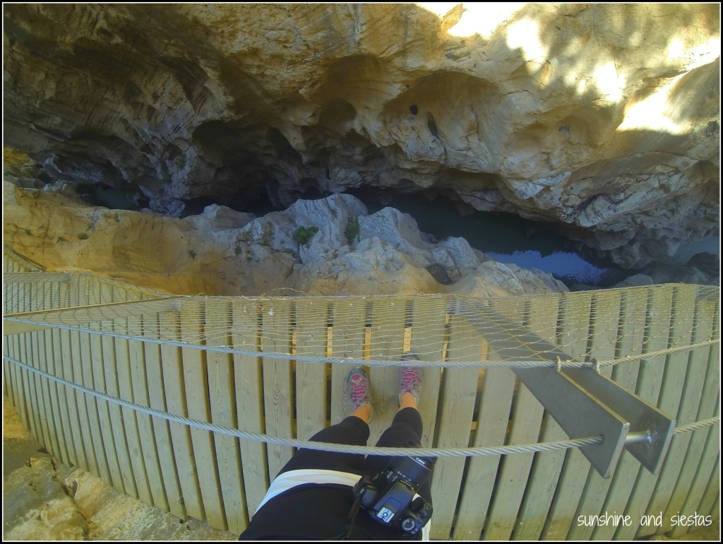
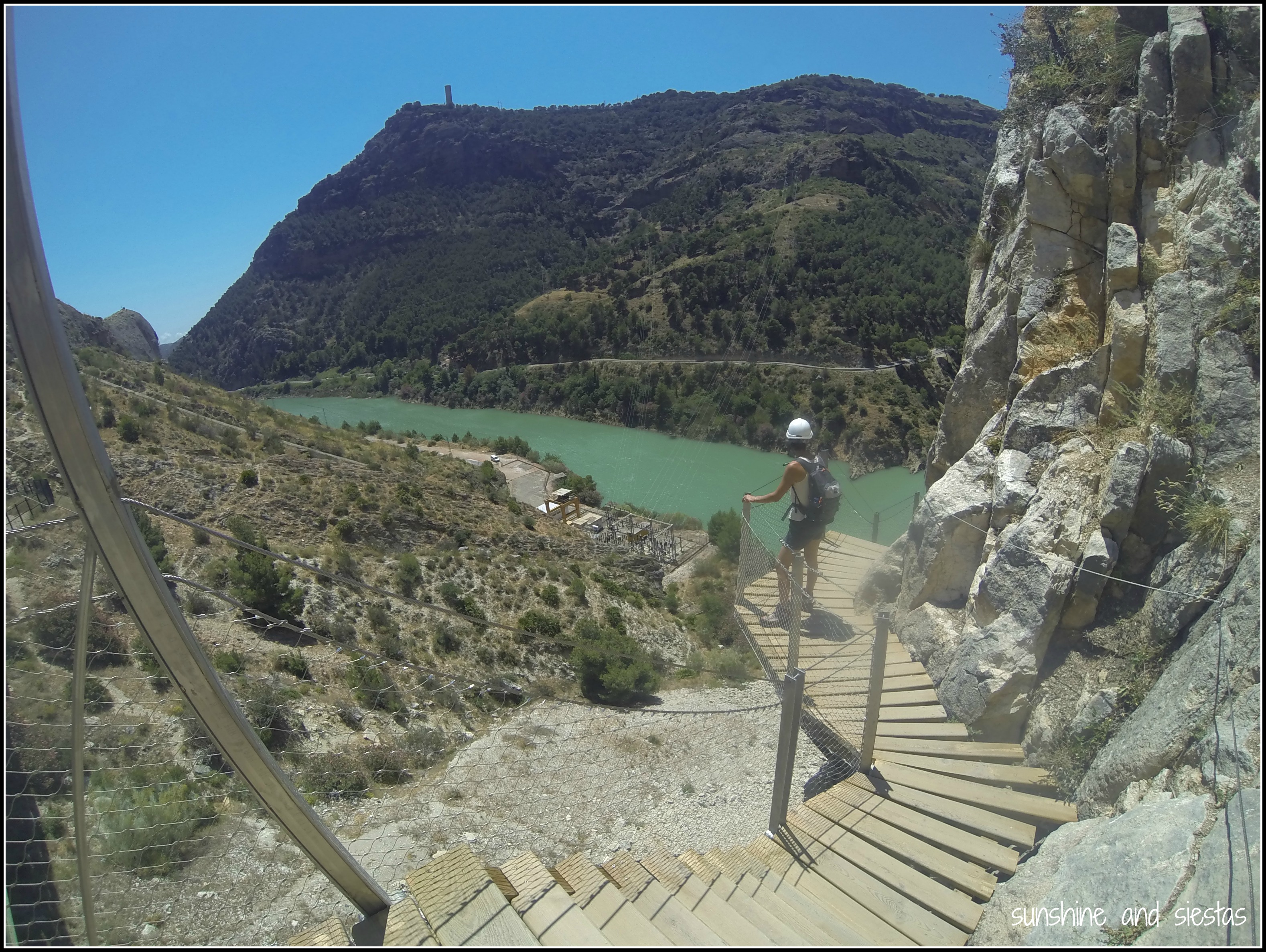
I wobbled a bit on the stairs that led to a 200-foot stretch of wooden pathway, stepping awkwardly as I tested out my nerves. The same wind that nearly blew an umbrella into me at the bar an hour earlier had picked up. My steps down became sideways to put as much ground under me as possible.

I’ve never been afraid of heights as a former gymnast, so I had no images of falling to my death when I entered the tramo of walkways just past the control cabin – I was more afraid of dropping my ID card or cell phone after taking panoramic shots of the gorge and damn below.

Crossing the Caminito del Rey

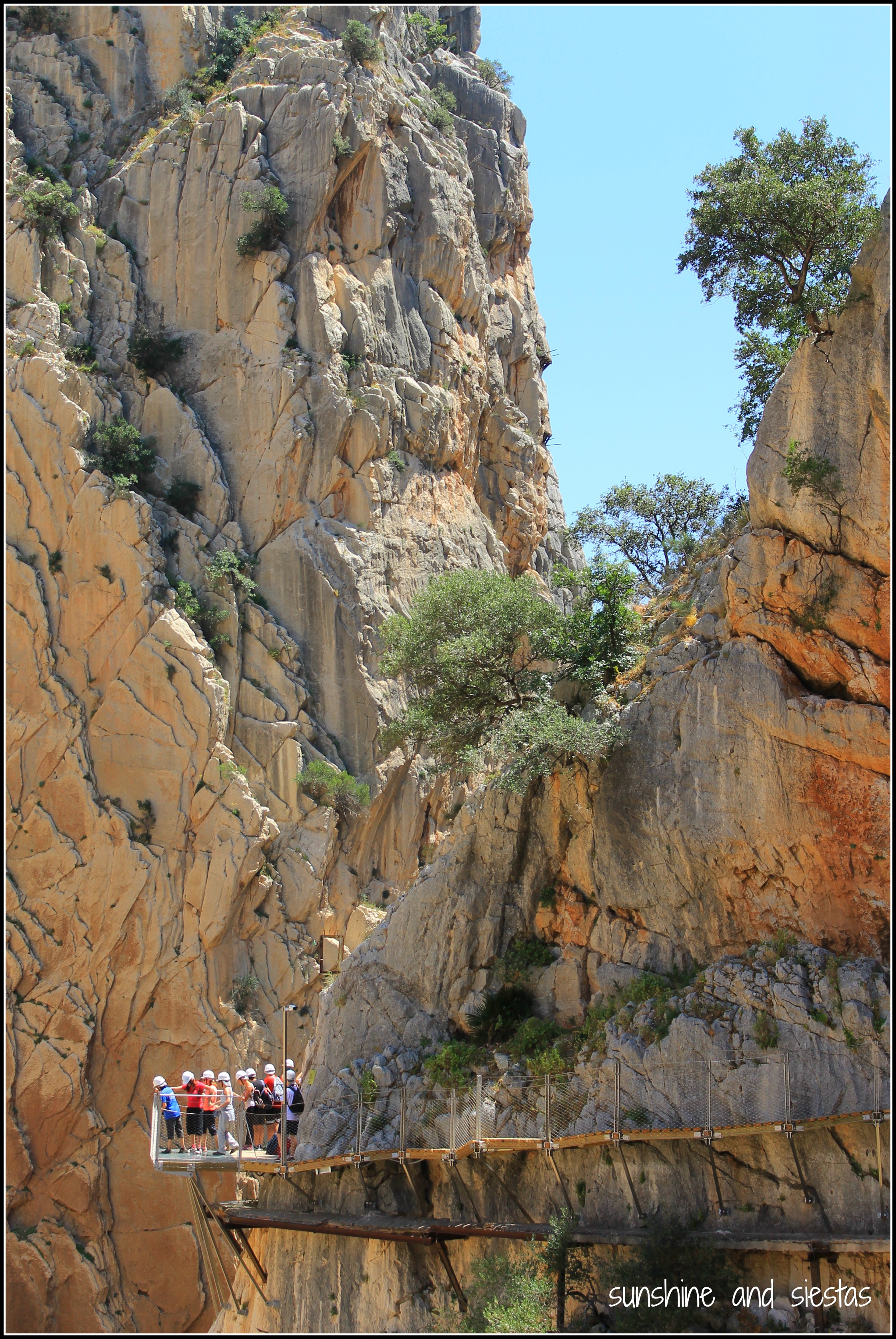
German, French and Spanish tourists clogged the beginning of the trail, as many were returning the same way they’d come (and hugging the rocks, making it easy to pass by them). Because the path is linear, hikers now have the choice of entering from the north or south, and of returning by bus or on foot, crossing the desafiladero once more.

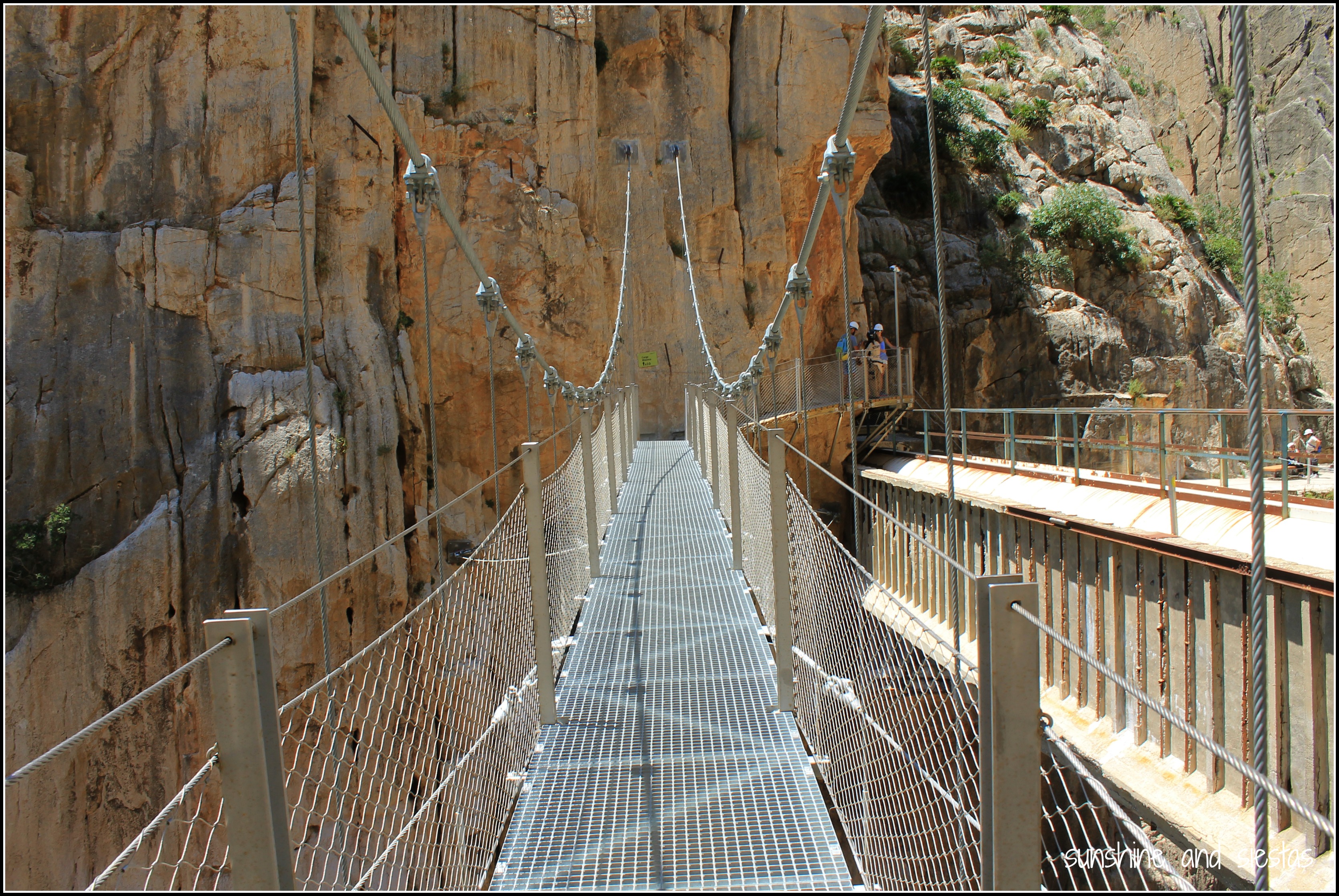
As if a death by fire rather than rocks were necessary, the first big moment from the south entrance is crossing the suspended bridge. Spanning the gorge, it’s the most exposed you’ll be to the elements on the whole trek.

Hanging Bridge in Malaga

Posing for a photo on the Caminito

Many parts of the old path have been left as a reminder of the origins of the route – I was either walking directly over it or just above it. In fact, when the Caminito was provisionally closed in 2000, the local government actually demolished the beginning stages to discourage climbers. This only made the leyenda negra grow and attract daredevils from around the globe.

the Old Pathway of the Caminito del Ret

the pasarelas of the Caminito

Pathways between the mountains on the Caminito del Rey

puente del rey

The Caminito is extremely tame since the reopening. At no moment did I feel like I was going to blow off the side of the gorge or lean too far over the railings. I wasn’t terribly disappointed – the day was sunny and temperate, the views of the Valle del Hoyo and the Pantano were as jaw dropping as the gorge itself, and I, for once, wasn’t attached to my computer.

Malaga Caminito del Rey

Hiking in Spain on the Caminito

Traversar el Caminito del Rey
When is the Caminito open? Do I need reservations? 

The Caminito del Rey is open every day but Monday, weather permitting. You MUST have a reservation to enter, as only 50 visitors are allowed every half an hour. I snagged a free entrance through the website a few weeks before the reopening.

What should I bring? Are there restaurants on the Caminito?

are there restaurants near the caminito del rey

Be sure to bring sunscreen, water and sturdy shoes. You’ll also need your entrance ticket and ID card or passport. There are no facilities along the trail – not even garbage cans – so you should use the bathroom and pack any food or water you might want to consume.

How can I get to El Chorro?

El Chorro is a neighborhood of Álora, located just up the hill from the visitor’s center. There are various ways to get there by car, but often on poorly serviced highways. From Seville, I took the A-92 towards Granada, turned south at Osuna and headed to Teba, turning off at Ardales and onto the MA-4503. The whole trip took just over two hours.

access point of the caminito del rey

From Seville, the Media Distancia train towards Málaga will also leave you in a train stop marked ‘El Chorro,’ and vice-versa. Schedule here. Due to road closures along the MA-5403, the train trip is probably preferred in summer 2015 – it will take the same amount of time and cost you the same amount of money from Seville as a car will.

How long is the Caminito, and how long should I plan to be in El Chorro?

The most famous part of the Caminito is, without a doubt, the walkways. Now equipped to support up to 50 people at a time and featuring handrails, the walkways, called pasarelas, constitute about three kilometers one-way.  

Valle de los Hoyos Málaga

There’s a 1.6 kilometer trek uphill to the official entrance point of the walkways from the southern access at El Chorro, another 2 or so in the Valle del Hoyo between them, plus 2.7 to the northern entrance point in Ardales. Round-trip is close to 14 kilometers round-trip, so plan on 4-5 hours. If you don’t want to walk back, you can grab a bus once an hour, whose schedule is here.

More information is available on the Caminito website.

Looking for more outdoor activities in Southern Spain? Check out my articles on the Vía Ferrata, the Minas de Riotinto and the Via Verde.

Photo Post: La Hermandad Rociera de Triana and the Pilgrimage to El Rocío

“No, no, no,” Lucía shook her head fiercely as curls of white smoke escaped from her lips. “You shouldn’t be in Cerro de Águila by yourself. Crime is rampant over there.”

That following morning at the Novio’s new house in Cerro, I was woken up by the fourth-floor shaking as what sounded like a loud pop boomed throughout. I ran into the bathroom and slammed the door behind me.

Turns out the potential guns from the ‘crime capital’ of Seville were actually noisemakers of the neighborhood’s religious brotherhood.

t

Fifty days after Resurrection Sunday, those faithful to the Virgen del Rocío (which is practically all of Southern Spain) make a pilgrimage towards La Aldea, a small hamlet full of stately mansions and dirt roads. The striking hermitage – a grandiose white mirage set at the southern edge of la Aldea with views to the marshes of Doñana National Park – was first built on the supposed spot where Alfonso the Wise found an effigy of the Virgin Mother. Today, it’s popular for its most raucous fiesta in the middle of the springtime. 

Seville counts five hermandades – Savlador and Triana are the most famous – whose numbers are staggering. On the Wednesday before Pentecost Sunday, covered wagons pulled by oxen, horses or even tractors set out towards the Almonte and la Aldea, following a silver-laden carriage with an image of the Rocío known as a simpecado. For many of the devout, this spiritual cleansing, characterized by sleeping and eating outdoors, song and dance and prayer, is the most important part.

IMG_4878

When I worked in Olivares, many of my students went missing in the days leading up to El Rocío and the days surrounding Pentecost. I had a handful named Rocío or Paloma in homenage to the Virgin Mary who, quite possible, is the most revered in Andalucía. 

Few things get me out of bed before 8am, but today I was already out the door at that time, Camarón fully charged and ready to shoot (the cohetes would have woken me up regardless). Mass at the chapel on calle Evangelista began at 7:30am, and the simpecado, preceeded by horses and pilgrims, left shortly thereafter. In the past, the carretas that carry supplied for the ten-day pilgrimage were allowed to traverse Triana, but city ordinance now mandate that the wagons start from Plaza Chapina at the northern end of the neighborhood.

romeros ready for El Rocio

Devout pilgrims at el Rocio

Romeros on Calle Pureza Triana

I followed the crowd to Calle Pureza and the door of the Esperanza de Triana church. Here, in one of the most emblematic monuments of the barrio, the simpecado would pass, the devout would pray and the pilgrimage would truly begin.

Perched on the curb just opposite the gleaming white temple, itself a nod to its marisma counterpart 70 kilometers west, I watched as romeros – the name for pilgrims around these parts – flooded the streets. Men wear straw hats and women don flamenco dresses that are easier to walk in, all clutching medals that bear the Virgen del Rocío.

Rocio Fashion 2015

carretas of El Rocio

Gitanas El Rocio

A three-piece band led the procession. Sevillanas with a twist, rocieras use a cane and a bass drum instead of cajas and flutes in place of guitars, and singers belt out songs proclaiming the glory of the Blanca Paloma. Behind them came romeros on horseback and the image of the Virgen herself.

music of el Rocio

prensa en el rocio

Triana to El Rocio on horseback

romeros
Romeros de Triana 2015

Calle Pureza during El Rocio

El Rocio passing by the Esperanza de Triana

Once the simpecado had reached the door of the church, pulled by two oxen, a man on horseback removed his had and, red faced, began to rally.¡Viva La Virgen del Rocío! ¡Viva la Blanca Paloma!¡Viva la Marismeña! Each battle cry was followed by a hearty ¡Viva! 

“¡Y Viva Triana! ¡Viva Triana! ¡Viva Triana!”

Salida del Simpecado Rociero


Everyone around me erupted into song as petals were thrown from the roof of the church. While El Rocío has a steady dose of hedonism, the true root of the festival lies in soul-stirring devotion. I felt moved in the same way that Semana Santa touched me. People stopped shoving and began to cry, crossing themselves as they proclaimed that only in Heaven is the Virgen del Rocío more loved.

Want to read more about the festival? I attended the Pentecost Sunday activities –¡vestida de gitana! – in 2012.

Autonomous Community Spotlight: The Principality of Asturias

Not one to make travel goals, I did make one when coming to Spain: travel to all 17 autonomous communities at least once before going home. While Madrid, Barcelona and Seville are the stars of the tourist dollar show (and my hard-earned euros, let’s not kid around here), I am a champion for Spain’s little-known towns and regions. Having a global view of this country has come through spending ample time in Andalucía, Galicia and Castilla y León – vastly different in their own right – plus extensive travel throughout Spain. 

Asturias and I have a special relationship – the Novio’s mother was born in Pola do Siero, making him as asturiano as he is andaluz. By the time we made the long drive to Asturias during my spring break in 2009, I was already in love with the region nestled between the Bay of Biscay and the Picos de Europa.

The small region is one of Spain’s wettest and, in my opinion, its most naturally beautiful, and the only autonomía considered a principality. Asturies, as its called in the local gable language, was also the starting point of my Camino de Santiago – Hayley and I walked from the industrial port of Avilés.

And it goes without mention that I love fabada and cidra.

Name: Asturias

Population: 1 million

Provinces: Just one, though Asturias has eight comarcas: Avilés, Caudal, Eo-Navia, Gijón, Nalón, Narcea, Oriente and Oviedo.

When: 12th of 17 regions, March 2009

About Asturias: It’s believed that the area has been inhabited for millennia by the Celts, but Asturias rose to fame in 722 during the Muslim Reconquest of Spain. Hiding in the caves at Covadonga, Don Pelayo is believed to have had the Virgen Mary appear to him, and she told him to rally and fight the Moors. He became the first king of Asturias and the region became a refuge for nobility until the Peninsula was once again under Christian rule.

The Novio tells me Asturians are 100% Spanish because the Picos de Europa blocked the peninsular conquest of the Moors. Considering it’s still a reino, it still has its rulers – Prince Felipe and Princess Leticia are next in line to the Spanish throne.

Must sees: Like Andalucía, I don’t even know where to begin, except for saying that your best bet for traveling in Asturias is by car. There are buses and FEVE trains across Asturias, but the service is infrequent, and there’s tons of encanto in many of the small towns that you shouldn’t miss.

The capital of Asturias is Oviedo, a small city with a huge cidra scene. Calle Gascona is known as La Ruta de la Cidra, and has cider bars lining the streets. There are also pleasant pockets throughout – the plazas, the old man bars, the green spaces, the old Romanesque churches. I highly recommend the bar Platero y Yo for their cachopo – the north’s answer to a flamenquín – and excellent wine list.

Gijón is a pleasant, seaside city with colorful buildings and a bustling port, and nearby, industrial Avilés has a well-kept old town. But Asturias’s best is in its small towns, many of which we passed through on the Camino del Norte – Cudillero, Luarca, Tapa de Casariego, Ballota.

East of Gijón, there are other hamlets worth exploring, as well. After visiting family friends in misty Infiesto, we spent two nights in Cangas de Onís and used it as a base to make it to Ribadasella, Poo, the caves and cathedral of Covadonga.

The beauty of Asturias is astounding, as well. When packing for the Camino, I made sure to bring a swimsuit for the untouched beaches we hugged as we walked for five days along the coast. You can’t miss the Lagos de Covadonga, one of Spain’s highest chain of lakes, nestled in the Picos de Europa. If you love the outdoors, Asturias couldn’t be any more perfect. 

Asturian culture is based largely in its celtic origins, including bagpipes! It’s also a literary region that takes art and theatre very seriously, and sports greats Fernando Alonso and David Villa are from Asturias – must be all of that milk. Asturias is also home to bable, a language that changes its vowels around. Case in point, the greatest youtube video of all time:

My take: Asturias is exactly like all of those Leche Asturiana ads – rolling green hills, tons of dairy cows and virgen beaches. If you couldn’t already tell, I love its paraíso natural, its jovial and grounded people (my mother-in-law included!) as well as its food.

Each month for the next 14, I’ll take a look at Spain’s 17 comunidades autónomas and my travel through them, from A to, um, Valencia. I’d love your take on the good and the bad in each one, so be sure to sign up for my RSS feed to read about each autonomous region at the end of each month! Next up for May is the Balearic Islands.

Read more about Andalucía and Aragón

Have you been to Asturias? What do you like (or not) about the region?

Spain Snapshots: A Visit to Spain’s Highest Point, el Teide

The Megane steadily climbed out of Santa Cruz de Tenerife, past La Laguna and into the plush interior of the island. The pines and windy roads took me back to Colorado, but with an occasional glimpse of Atlantic waters.

Gua guas pushed up the hill slowly, and Forrest swerved around them, comfortable as he shifted into third in our rental car and rode the mountain up. Tenerife was formed by an underground volcano 30 to 50 million years ago, and its highest point, Teide, actually gives the island its name: tene (mountain) and ife (white), joined by an /r/ during the colonial period. The entire island is formed from volcanic rock, in fact, evident from the steep ride up and down, and the white-capped mountain is visible from seemingly every rincón of the largest island in the archipelago. 

Once we reached the national park and UNESCO World Heritage site, we parked the car and took the gondola up the mountain. Most tourists don’t venture up to the top, standing nearly 3800 meters above sea level, despite Teide being one of the most visited sites in Spain. The landscape is almost barren, and the only sign off life we saw after starting our ascent were lizards.

Steep rock stairs have been carved into the rock face, but we still scrambled over boulders, stopping for vistas and water breaks every 10 steps because the air was so thin. 

The great crater caused by multiple eruptions in visible from just about everywhere on the island, but seeing it from a bird’s-eye-view was insanely cool.

From the very top, you can see Gran Canaria to the east and la Gomera to the west. We actually hiked above the cloud level that covers the occidental side of the island, watching them get burned off by the warm midday sun.

If you go: Visitors can take the gondola up the mountain at the cost of 25€. If you want to hike to the top, you’ll need to print off an access pass on the national park’s main page. It’s free, but you’ll have to bring a form of ID.

Be sure to dress in layers, as it’s cold at the top, and wear comfortable shoes. Bring sunscreen, sunglasses and plenty of water, as there are no facilities after leaving the visitors center.

Have you ever visited a national park in Spain?

My rental car was graciously provided by Car Rentals UK. All opinions (as well as the memories of my stomach dropping during the hairpin turns) are my own.

Climbing the Via Ferrata of Archidona

Something hard hit my boob. I watched a rock about the size of a plum careen down the grassy knoll before rolling to a stop. I squinted up at the rock face. There was a lot of mountain to go, and it had already beaten me up.

The via ferrata is the Italian name given to the iron railings the Italian army used in WWI to scale the Alps and the Dolomites, which may have existed a century or two before. The peñón of Archidona is certainly not the Alps, but as a first time climber, my legs were shaking before I had even strapped my kit to the long wires extending more than 140 meters vertically.

Franci explained the procedure to us once more –  to use the mountains, take off one carabiner at a time and don’t panic. I watched Meg Spiderman crawl over the first half a dozen before I took a deep breath and pushed off the ground, grasping the iron peg above my head.

Reaching the top a few hours later (there were periods of waiting for slower climbers or turns to cross the bridge that spanned a canyon) was a tad anti-climactic because my legs were tired and I’d already seen this view of the town below and the mountains that enclose it. My hands were red and raw and I could feel my nose burning under the hot sun.

We started down the mountain – this time walking – and snaked back around to the cars.

Facing things that make me nervous gives me just as much satisfaction as a really good meal and a glass of wine. Yeah, I like being outdoors and trying new things, but I’m not an adrenaline junkie. That said, I’d consider doing other activities that Ocioaventura offers, like spelunking or rafting. Anything that allows me to keep my two feet on the ground!

Ocioaventura offers a half-day Via Ferrata pack, which includes equipment rental, insurance and a basic training course, plus the climb, for 45€. Be sure to wear comfortable clothing and shoes, put on sunscreen and eat beforehand. You’re able to carry a small backpack for water. The course in Archidona is for beginners and can be climbed in 2-3 hours.

And if you’re looking for a place to stay, be sure to check availability at Almohalla 51, a beautiful boutique hotel that will only require a quick uphill trek from the main square.

Spain Snapshots: The Medieval City of Mondoñedo along the Camino de Santiago del Norte

Leaving Lourenzá at just past 7am, we’d have a two hour hike before reaching Mondoñedo, where we’d agreed to meet Iván, Claude and Sandrine for breakfast. While we’d stop and feed our bodies whenever we felt hunger pains or a bit of weakness, this day was different – we’d need to double our intake of toast and coffee for a three-hour hike straight upwards into Gontán.

Not only was this the day we had to climb a mountain, but also the day we couldn’t lose MC. Hayley and I both cried silent tears to ourselves from pain, from frustration, from just needing to let out what our emotions were trying to say. It was a long day, and a pivotal one during the trek, where I nearly broke the promise I made to myself to walk every goddamned step to Santiago by checking bus schedules.

As we descended the lush valley into the small city of Mondoñedo around 9am, I took a misstep and felt a weird pain creep up my left calf. Remembering my years as a gymnast, it felt like tendonitis. I grasped at it in pain, trying to sooth the sore area by walking on on my heels and pulling out my mobile to check bus times out of the city.

Mondoñedo is one of the original capitals of the Galician kingdom and a city with more than 900 years of history. Its most famous landmark is its cathedral and rectory, known as a catedral arodillada for its squat spires. It was breathtaking and the backdrop for a lively market that morning under a soaring sun.

Climbing straight out of the city, we turned around to glimpse the village as the sun began to burn off the mist that had become synonyous with our mornings along the Camino. Thankfully, leaving Mondoñedo was quicker than savoring the entrance to it.

In the nearly six months it’s been since we reached Santiago on foot, but the quick stop in Mondoñedo has stayed with me, both for the views and the valley, as well as the day I decided to grit my teeth and prove to myself that I could handle an uphill climb, both mentally and psychically. 

Have you been to the Lugo province? 

Related Posts Plugin for WordPress, Blogger...